


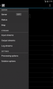
RTKGPS+
Perihal RTKGPS+
+++++++++++++ DISCLAIMER ++++++++++++++
THIS IS AN ALPHA VERSION
I received some requests to move it to a production
version, for my point of view it works but this version
lacks some extensive tests.
However I changed it to public with this disclaimer.
IT IS PROVIDED AS IS...
WITHOUT ANY WARRANTY.
++++++++++++++++++++++++++++++++++++++
Android RTKLIB frontend.
source code can by downloaded on https://github.com/eltorio/RtkGps
Heavily based on RtkGps from Alexey Illarionov, this is a fork of his work. He allows explicitly to modify and redistribute his work only with the distribution his copyright. You'll find the original license in the "About/Legacy Info" screen. Thanks to all contributors to respect this original license clause.
Since there is no new version I reworked the code for adding some features I need:
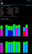
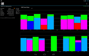
1- show the altitude in the status view.
for activating this you need to choose Height:Geodetic in the "Solution Options" view
2- send mock locations to other applications.
for activating this you need to check in the "Solution Options" view Output GPS mock locations, but this is only working if you have allowed "mock locations" in the developer settings (in Android setting).
today (in 1.0alpha13) the mock locations are not usable in the Google map API.
3- automatically upload log file or solution file to your Dropbox account
4- can generate a gpx file of the track
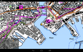
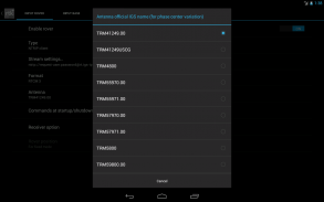
5- can display the result in ECEF, WGS84 Lat/Lon, NAD83, Lambert 93 (RGF93) or UTM (with auto zoning) coordinate system
5b- use any Proj4 projection
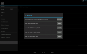
6- can display ellipsoidal height or geodetic altitude (different geoid models can be use see: https://github.com/eltorio/RtkGps for how to install a geoid model)
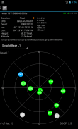
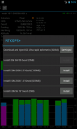
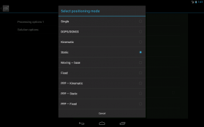
7- use any RTKLIB compliant GNSS with raw output connected via USB (ACM/PL2303/FTDI), Bluetooth, TCPIP or NTRIP
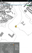
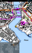
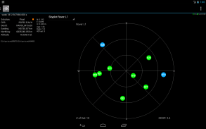
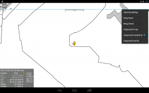
8- can display some maps coming from IGN Geoportail (cadastral parcels, satellite, roads), OpenStreetMap Mapnik, Bing (satellite, roads).
9- can download and use IGS ultra-rapid ephemeris
This software is a port of RTKLIB 2.4.2p9 developed by Tomoki Takasu (http://www.rtklib.com), if you do not know what this application is; this application is probably not what you are looking for!
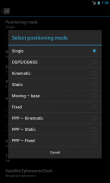
This application can compute precise GPS positions using RTKLIB algorithms (RTK or PPP) but for this you need a supported -external- GPS with raw carrier phase output.
This is not a "standard" GPS like those embedded into your phone or your car, the cheapest one you can find is something like uBlox LEA-6T .
THERE IS NO WAY to use the GPS found in Samsung Galaxy(s) nor any phone I seen.
But there is a special test mode witch use the internal GPS for testing only, obviously none of the precision algorithm found in RTKLIB can be use.
+++++++++++++ PENAFIAN ++++++++++++++
INI ADALAH VERSI ALPHA
Saya menerima beberapa permintaan untuk menggerakkannya untuk pengeluaran yang
versi, untuk pandangan saya ia berfungsi tetapi versi ini
tidak mempunyai beberapa ujian yang meluas.
Walau bagaimanapun, saya menukarnya kepada orang ramai dengan penafian ini.
ADALAH DISEDIAKAN SEBAGAIMANA ADA ...
TANPA SEBARANG WARANTI.
++++++++++++++++++++++++++++++++++++++
Android RTKLIB frontend.
kod sumber boleh dengan turun pada https://github.com/eltorio/RtkGps
Sarat berdasarkan RtkGps dari Alexey Illarionov, ini adalah garpu karyanya. Beliau membenarkan jelas untuk mengubah dan mengagihkan semula karya beliau hanya dengan pengagihan hak cipta beliau. Anda akan mendapati lesen asal di dalam "Kira-kira / Legacy Maklumat" skrin. Terima kasih kepada semua penyumbang untuk menghormati klausa lesen asal.
Kerana tidak ada versi baru saya diolah kod untuk menambah beberapa ciri-ciri yang saya perlukan:
1- menunjukkan ketinggian memandangkan status.
untuk mengaktifkan ini anda perlu memilih Tinggi: Geodetik dalam "Penyelesaian Pilihan" Pandangan
2- hantar lokasi olok-olok ke aplikasi lain.
untuk mengaktifkan ini anda perlu menyemak dalam "Penyelesaian Pilihan" Pandangan Output GPS lokasi olok-olok, tetapi ini hanya bekerja jika anda dibenarkan "lokasi olok-olok" dalam tetapan pemaju (dalam suasana Android).
hari ini (di 1.0alpha13) lokasi olok-olok tidak boleh digunakan dalam Google map API.
3 secara automatik memuat naik fail log atau fail penyelesaian ke akaun Dropbox anda
4- boleh menjana fail GPX trek
5- boleh memaparkan hasil dalam ECEF, WGS84 Lat / Lon, NAD83, Lambert 93 (RGF93) atau UTM (dengan zon auto) sistem koordinat
5b- menggunakan mana-mana unjuran Proj4
6- boleh memaparkan ketinggian elipsoid atau ketinggian geodetik (model geoid yang berbeza boleh digunakan lihat: https://github.com/eltorio/RtkGps untuk bagaimana untuk memasang model geoid)
7- penggunaan mana-mana RTKLIB GNSS mematuhi output mentah disambungkan melalui USB (ACM / PL2303 / FTDI), Bluetooth, TCPIP atau NTRIP
8- boleh memaparkan beberapa peta yang datang dari IGN geoportail (bidang kadaster, satelit, jalan raya), OpenStreetMap Mapnik, Bing (satelit, jalan raya).
9- boleh memuat turun dan menggunakan IGS Ephemeris ultra-cepat
Perisian ini adalah pelabuhan RTKLIB 2.4.2p9 dibangunkan oleh Tomoki Takasu (http://www.rtklib.com), jika anda tidak tahu apa permohonan ini adalah; permohonan ini mungkin apa yang anda cari!
Permohonan ini boleh mengira tepat kedudukan GPS menggunakan algoritma RTKLIB (RTK atau PPP) tetapi untuk ini anda memerlukan GPS -external- disokong dengan output fasa pembawa mentah.
Ini bukan satu GPS "standard" seperti yang tertanam ke dalam telefon anda atau kereta anda, salah satu yang paling murah anda boleh mencari sesuatu seperti uBlox LEA-6T.
TIDAK ADA CARA menggunakan GPS yang terdapat dalam Samsung Galaxy (s) mahupun mana-mana telefon saya lihat.
Tetapi ada satu khas mod ujian sihir menggunakan GPS dalaman untuk menguji sahaja, jelas tiada ketepatan algoritma yang terdapat dalam RTKLIB boleh digunakan.
RTKGPS+ - Versi 1.0 Alpha 26
(10-04-2020)RTKGPS+ - Maklumat APK
Versi APK: 1.0 Alpha 26Pakej: gpsplus.rtkgpsVersi Terkini RTKGPS+


 3.64
3.64


Aplikasi dalam kategori sama

Anda juga mungkin suka...


